A few thoughts on maps
I spend a lot of time looking at maps, mostly digital ones. The ease of accessing maps online makes me think of people not so long ago whose maps still had uncharted territories. Joseph Conrad writes in Heart of Darkness:
Now when I was a little chap I had a passion for maps. I would look for hours at South America, or Africa, or Australia, and lose myself in all the glories of exploration. At that time there were many blank spaces on the earth, and when I saw one that looked particularly inviting on a map (but they all look that) I would put my finger on it and say, 'When I grow up I will go there.' The North Pole was one of these places, I remember. Well, I haven't been there yet, and shall not try now. The glamour's off. [...] But there was one yet—the biggest, the most blank, so to speak—that I had a hankering after.
Looking at different versions of maps reveals a lot. Topographical maps sometimes demonstrate why borders are the way they are (e.g. the protruding part of northeastern Afghanistan follows a valley instead of being arbitrary1). Soil maps explain nicknames like Ukraine as "the bread basket of Europe" and part of the Middle-East as "the Fertile Crescent". Mineral maps, language maps and logistical maps can explain reasons and outcomes of wars, both past and current. And the list goes on...
Most of all, I like looking at street views and wondering what life is like in those places. I don't know what it's like to live next to a mountain looming over a city, but an online visit to Yerevan, Armenia or Sapporo, Japan can help me try. I imagine the impression it makes when a giant cliff suddenly appears through the gaps between high rises. Or I can zip through town, checking if the peaks are snow-capped in different seasons.
***
I recently read a piece on an Uzbek migrant worker in Moscow. He's from the Fergana region of Uzbekistan, but when I tried to visit it virtually, I couldn't. The Google car hasn't driven through much of the country apart from a few bigger cities. Sometimes, people in places that don't have street view coverage upload the it themselves. But not in Fergana, Uzbekistan.
I wonder why. Do they use a different service? Or, just generally speaking, isn't having an online presence that important there? Or do they feel that they don't want to do free work for a tech giant? Or has Uzbekistan limited where the Google car can go?
In any case, the streets of Fergana are a "white space" for me. It's not quite the same as an entirely blank map for Conrad, but it does evoke a sense of wonder. And a "hankering after".
***
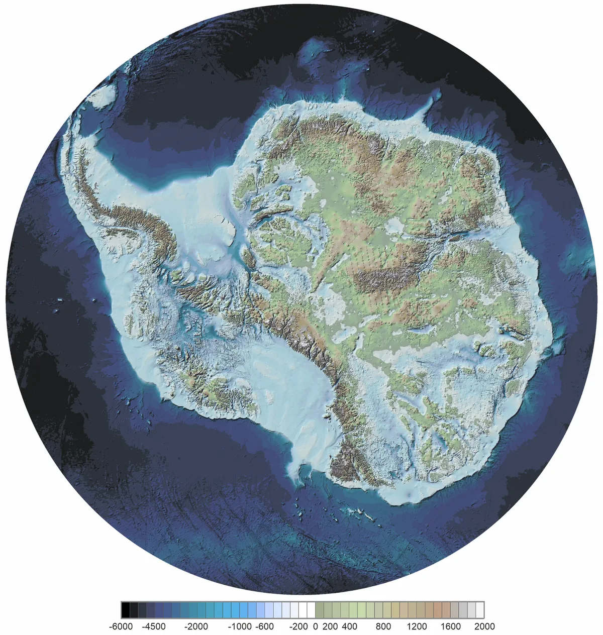
I also came across a news piece that the actual continent of Antarctica, under all the ice, has recently been imaged more accurately than ever before. The generated photo2 is stunning. After looking at maps for so long (I'm sure that my time on Google Maps is measured in weeks), it's amazing to see all the geographical features. It's not common to see such a big part of Earth with new eyes.
If it were as warm as any other continent, who'd live on Antarctica now and what kind of history would it have? What kind of names would the bays and mountains have if they were actually live in, as opposed to just superficially explored by visitors? Would the continent's name itself be something more personal than just "opposite to the north"? And what secrets are preserved beneath the ice from the time when Antarctica really was warm?
That being said, the 3½-hour time difference between Afghanistan's Wakhan Corridor and neighbouring China is pretty crazy.↩
Pritchard et al. Scientific Data (2025). Extra label removed. Image source.↩